Rainfall still in region’s forecast, expected to clear before next week

Posted Aug 9, 2026 08:04:10 AM.
Last Updated Aug 10, 2026 06:50:39 AM.
Another week with heavy rainfall is in the books, though the Waterloo Region isn’t clear of wet weather yet.
Rain and a tornado warning rolled through the region yesterday, causing multiple events to be cancelled or paused. The Kitchener Blues Festival was one of those events, though after the rain cleared, the event continued.
Prepare for a humid week of weather, with rain, clouds, and warm weather ahead; humidity levels could rise and remain throughout the week.
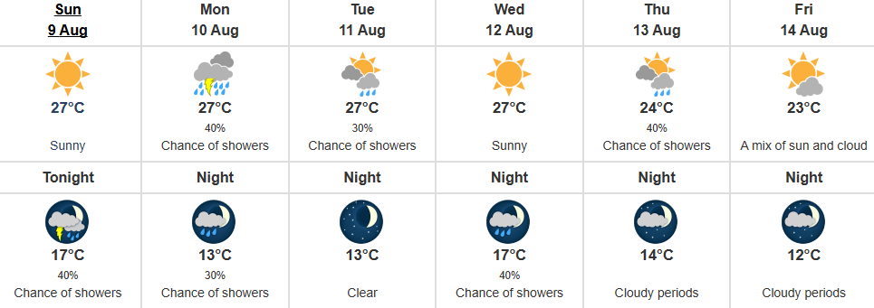
Clouds are expected to roll into the late afternoon and evening, bringing a 40% chance of rain and a risk of a thunderstorm overnight. Night time temperatures will drop to a low of 17 degrees.
Monday
Cloudy skies will stick around in the morning and heading into the afternoon, there’s a high of 27 degrees. There will be a 40% chance of showers and a risk of a thunderstorm during that time.
In the evening and overnight, skies will partially clear, with Environment Canada predicting a 30% chance of some showers, and a low of 13 degrees.
Tuesday
There will be a mix of sun and clouds, that will bring a small amount of rain throughout the day. Tuesday’s high is 27 degrees.
Now overnight, skies will clear, and temperatures will cool to a low of 13 degrees.
Wednesday
You will see more sunny skies through the day, where Environment Canada predicts a high of 27 degrees.
Overnight, cloud coverage is in the forecast, which will carry a 40% chance of rain overnight. There’s a low of 17 degrees.
Rest of the week
For the rest of the week, Environment Canada says you can expect a mix of sun and clouds. There’s a small chance of some rain on Thursday, but that clears going into Friday and the weekend. Temperatures will drop a little going into next week as well, with the average high hovering around 24 degrees.
Your Community