Weather station records hottest July in 70 years
Posted Aug 11, 2025 04:37:46 AM.
Last Updated Aug 11, 2025 02:13:56 PM.
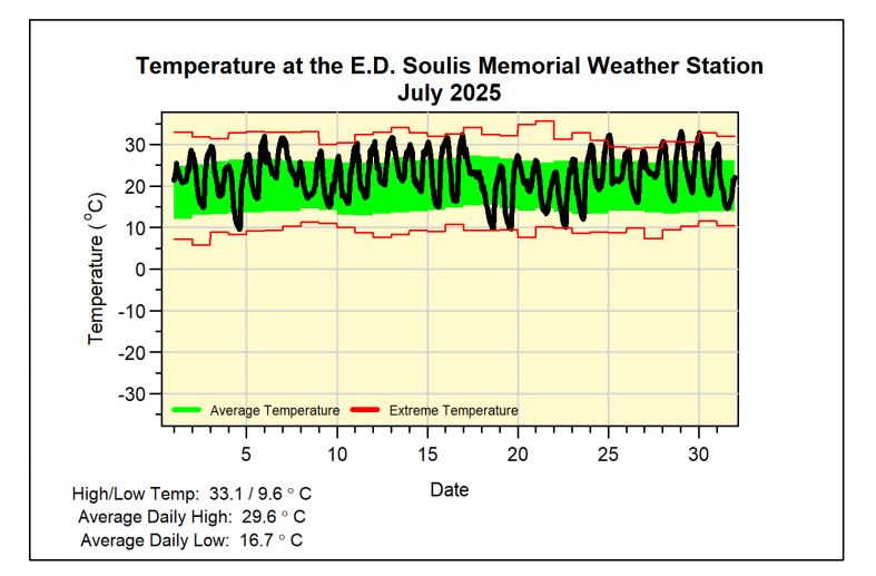
As the region continues to sweat through this latest heat wave, the E.D. Soulis Memorial weather station at the University of Waterloo is out with its weather statistics for the month of July.
No surprise: it was hot.
The weather station notes that last month was the fourth hottest in the history of local weather records, and the hottest July since 1955.
“With multiple heat waves throughout July and 18 days above 30 C, the average temperature was an amazing two and a half degrees above average,” its website reads.
The hottest it got was 33.1 C with an average daily high of 29.6 C. The long-term average daily high measures around 26 C.
Despite the heat and one really dry week at the beginning of the month, the weather station did record an above-average amount of rain.
“There were regular storms that came through, resulting in a total precipitation of 98.4 mm. This is above the average of 78.2 mm, but still within the average range.”
Take a closer look at the highs and lows below:
- Maximum Temperature 33.1 C
- Minimum Temperature 9.6 C
- Average Daily High Temperature 29.6 C (Long term average 25.6 C)
- Average Daily Low Temperature 16.7 C (Long term average 14.8 C)
- Total Precipitation 98.4 mm (Long term average 78.2 mm)
Weather